


7 tours
Guided Temple Tours
Guided temple tours, from old city walks and Doi Suthep to full days beyond the walls.
Old City, Chiang Mai
A 1980s gate on a site from 1296, and the starting point of the Sunday market. What to look at, what is old, and when to come.
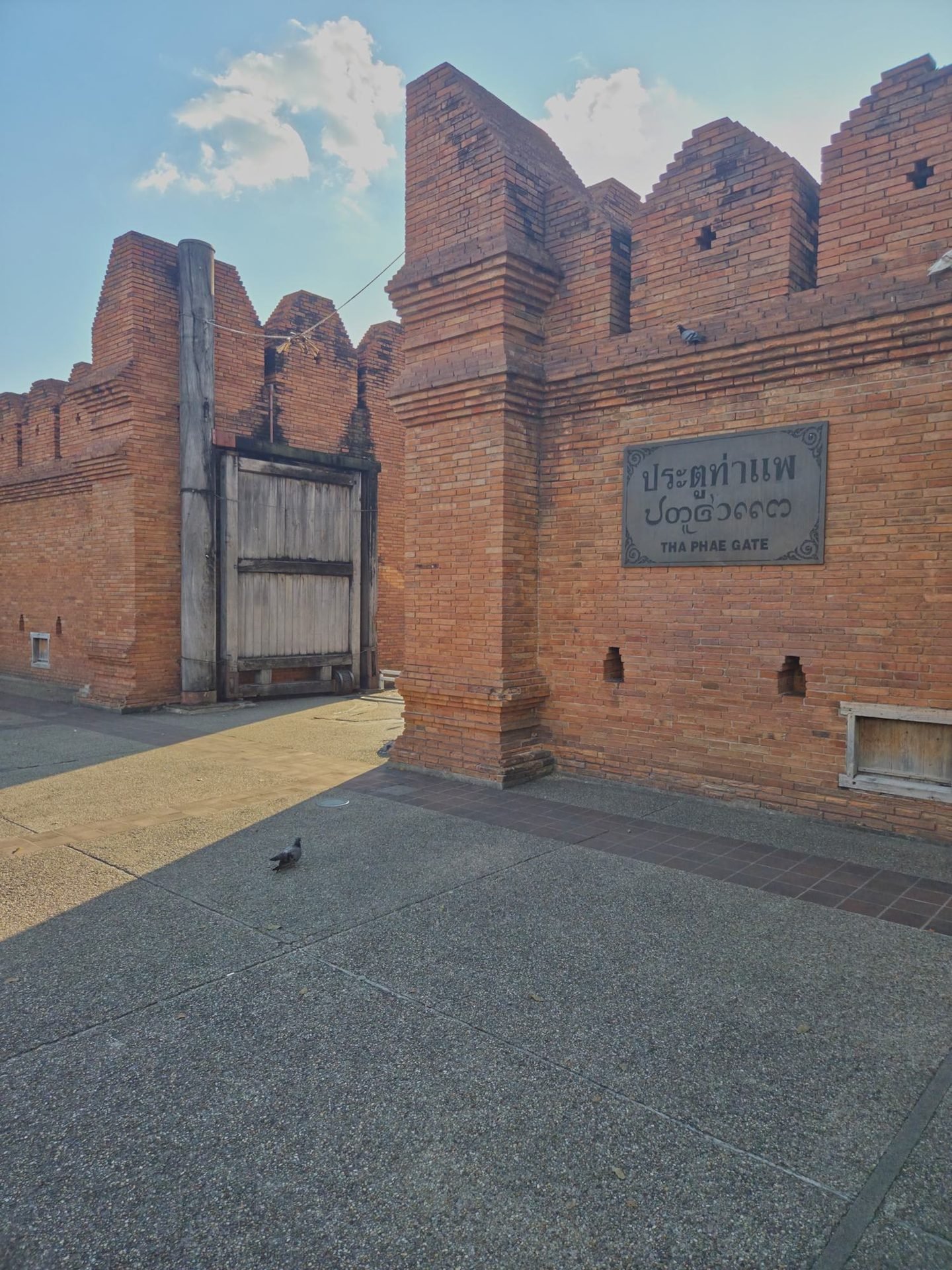
Tha Phae Gate is the east entrance to Chiang Mai's old city, the square of moat and walls laid out by King Mangrai from 1296. The brick gate and the stretches of crenellated wall on either side of it were rebuilt in 1985–86, from an old photograph and archaeological evidence. The site is more than seven centuries old; the masonry is not.1,2
It is free, open at all hours, and ten to twenty minutes is enough to see it. What makes it worth more than a photograph is knowing what you are looking at: why it carries the name of a raft landing on a river a kilometre away, what it was rebuilt from, and why the streets around it fill up on Sunday evenings, and the square on festival nights.
Our take: Worth a short stop, not a special trip. Come in the morning, when the sun should be on its outer face, or after dark, when the gate and its wall are floodlit, and pair it with the Sunday market or the temples of Tha Phae Road. In the late afternoon the outer face is in shade.
The masonry dates from the 1980s, but it copies an old form. Four details on the wall, four at the opening.
The wall beside the gate, read from top to bottom
The opening, from the square
The opening is not a monument behind a rope: people walk and cycle through it all day, between the square outside and Moon Muang Road inside. Tha Phae is also the only gate of the old city that still has a door, as Citylife noted in 2016.3
There is no ticket and no information panel about the reconstruction. Against the wall, to the right of the opening as you face it from the square (that is, to the north), stands a white stele, an inscribed stone slab between two posts; we could not read it, and we found no source that describes it.
What is old here is the place of the gate and the line of the walls. The gate itself has been taken down and rebuilt more than once.
Chiang Mai was laid out by King Mangrai from 1296 as a square of moat and walls, with a gate on the east side, towards the Ping River. That gate was not called Tha Phae. Its name was Chiang Ruak; Tha Phae, the raft landing, was the name of a second gate further out, in an outer earth rampart on the road to the river. In the 19th century the name spread to the inner gate, and it stayed there once the outer gate had gone.1
The brick gate you see was built in 1985–86. It was not restored from surviving masonry: it was drawn from an 1899 photograph of a Chiang Mai gate and from archaeological evidence, and the sources disagree on which gate it shows.1,2
The gate through the centuries
1296
from the chronicle.Mangrai founds the city; its east gate is Chiang Ruak
According to the Chiang Mai Chronicle, the city's own history, work on the moat and the walls began at the north-east corner and went on round the city. The east gate was called Chiang Ruak, after the stockade, ruak, put up around Mangrai's camp on that spot.1
1517
from the chronicle.The walls are rebuilt in brick
The chronicle records bricks moulded to rebuild the city walls under King Kaeo of Lanna, the northern kingdom that had Chiang Mai as its capital. The often repeated idea that Kawila, who resettled the city in the 1790s, was the first to build them in brick does not fit this entry.1
1531–1826
from the chronicle.Two gates, and a raft landing
A village called Ban Tha Phae, the raft landing, appears in the chronicle in 1531. In 1826 it still names two separate gates: Chiang Ruak, and a Tha Phae gate in an outer earth rampart, further east on the road to the river, which a research report places near today's Wat Saen Fang.1
late 1790s
sources disagree.Kawila resettles an empty city
After some twenty years of near abandonment, Kawila, the ruler who refounded Chiang Mai, brings people back and has the walls restored. The same report dates the refounding to 1796; the English Wikipedia, after a Thai chronicle, has him entering the city in February 1797.1,4,5
1873–1897
from the chronicle.Inner and outer Tha Phae
Under Inthawichayanon, ruler of Chiang Mai from 1873 to 1897, the old Chiang Ruak is already called the inner Tha Phae gate. A map of his reign shows it as a double gate. Once the outer gate had gone, the name stayed with the inner one.1
1899
1948–1967
sources disagree.Demolition, then a gate remade by the city
Long stretches of the walls come down to widen the roads. Thai Wikipedia dates the first demolitions to 1948, without a source; a 2025 Chiang Mai News article, which cites an essay by the historian Nidhi Eoseewong, has the gate itself taken down in 1960; the same research report places the works in the mid-1960s. In 1966–67 the municipal engineer repairs the two towers that by then flank the opening, and rebuilds the stretches of wall on either side.1,2,4,6
1985–86
dated.Today's gate
At the provincial governor's initiative, the gate of the 1960s is pulled down and a new one built, designed by a regional unit of the Fine Arts Department, Thailand's heritage agency, from the 1899 photograph and archaeological evidence, and built by the provincial public works. Some accounts run the work into 1987.1,2,7
2023
dated.A pillar found inside the gate
On 1 November 2023 a Fine Arts Department team opened a chamber built into the wall of the gate, which no one had opened for nearly forty years, and found an inscribed stone pillar, about 1.9 m tall, in Lanna script, one face written in mirror image. Set at the gate in 1966, it was removed when the works began in 1985 and placed in this chamber once the new gate was finished.2,7
Since 2015 the city has been on UNESCO's tentative list. The nomination filed in 2026 includes the walls, the moat, the five gates (Tha Phae among them) and the four corner bastions; a decision is expected in 2027. Chiang Mai is not a World Heritage site yet.9
The gate faces east, on the square side. That decides when its outer face is in the sun.
Nearly the same view, five days apart


The outer face, with the door and the plaque, looks east over the square: by the sun's path, it should be lit from sunrise until around midday. We cannot show it: all our daytime photographs were taken between 16:19 and 16:31, when that face was already in shade.

Both faces are floodlit from below once night falls. On our visit, a Tuesday at about 19:25, a few small groups were photographing each other in front of the plaque: part of the scene rather than an obstacle.

The gate is a hinge: the old city behind it, the road to the Ping River in front.
The square lies outside the wall and fills the gap in the moat: the water runs on either side of it, to the north and to the south. By our measurement on OpenStreetMap it is about 190 metres long and 55 wide. On its east side starts Tha Phae Road, which runs straight for about a kilometre to the Ping River at Nawarat Bridge; the road's name, the raft landing, points to that river bank. Through the opening, on the old-city side, Ratchadamnoen Road leads straight on to Wat Phra Singh.10

On Sundays, from late afternoon, Ratchadamnoen Road is closed to traffic and the market runs from just inside the gate to Wat Phra Singh, a little over a kilometre. It began in 2002 on Tha Phae Road itself and moved inside the walls in 2004. Published hours vary from one source to the next; our night-markets guide says when to arrive.11
The square is one of the city's main open-air stages: the municipal opening of Songkran, the Thai New Year, in April; the New Year countdown; and Yi Peng, the northern festival of lights at the full moon of the twelfth lunar month, usually in November. In 2025 the parade of krathong, the decorated offerings floated on the water, left from here at 19:00 for the municipal offices by the river. For 2026 the province has announced the festival for 23 to 25 November, and the main krathong parade is planned for 25 November; its time and route were not yet published when we checked.12,13,14,15,16
Sky lanterns are another matter. The province allows releases only on 24 and 25 November, from 19:00 to 01:00, and the Mueang district office has asked that none be released in the city: do not release one at the gate. Our Yi Peng article covers the festival and the lanterns.14,16
The gate also has a part in Suep Chata Mueang, the yearly rite to extend the city's destiny: it is performed at the same moment at ten points (the five gates, the four corner bastions and the city's navel at the Three Kings Monument). In 2025 it was held on 19 June, in 2026 on 4 June.17,18
East along Tha Phae Road, three temples with Burmese-style buildings: Wat Mahawan, about 3 minutes away; Wat Bupparam, about 7; and Wat Saen Fang, about 9, near the place where the outer Tha Phae gate is thought to have stood. West, inside the walls: Wat Chedi Luang, about 9 minutes, and the Three Kings Monument, about 10. Further on, Warorot market is about 12 minutes away towards the river, and Wat Phra Singh about 15, at the far end of the Sunday market. Walking times are our own estimates on OpenStreetMap.1,10
Checked in October 2026.

Municipal rules
No feeding the pigeons or buying food for them, no alcohol, no spitting, no smoking
Chiang Mai Municipality sign photographed on the square on 22 October 2026. It also asks you to mind your valuables and to keep the square clean.
Entry
Free, no ticket, open at all hours
A public square with no barrier and no ticket office: we saw none on 22 and 27 October 2026. During festivals, stages and road closures change the layout.
Time
10 to 20 minutes for the gate alone
Longer on a Sunday evening, when it is the starting point of the market.
Older guides promise a square full of pigeons and people feeding them. Today the municipal sign forbids feeding them or buying food for them, and in June 2026 the local press reported daily patrols from 08:00 to 20:00 and far fewer birds. Don't count on the pigeon photo.19
It is the easiest landmark to give a driver: Pratu Tha Phae, pratu meaning gate. Red shared trucks, the songthaews, cost 30 baht a person within the city in a 2024 report, but the driver may wait to fill up, or ask more for a private ride: agree the fare before you get in. The ride-hailing apps Grab and Bolt also operate in Chiang Mai. From Warorot market or the Night Bazaar, it is a walk of about a quarter of an hour at most.20
The square is flat and paved. We did not check every kerb at the crossings on Moon Muang Road, where traffic is heavy and one-way: cross at the lights.
Chiang Mai airport is about 4 km from the gate, well inside the 9 km radius around airports where drones may not fly without prior approval, and flights over built-up areas and crowds also need authorisation. A drone must also be registered with the civil aviation authority, the CAAT, and the telecoms regulator, the NBTC, and each flight declared on the CAAT portal at least three days ahead; flights are limited to daylight. In practice, do not plan to fly here.21,22
Four questions the sources leave open.
Which gate does the 1899 photograph show?
The 1985–86 gate was modelled on it. One book identifies it as the southern Chiang Mai Gate, another as the old Tha Phae; the research report we relied on says only 'one of the city's gates'.1,2
When exactly was the old gate pulled down?
Thai Wikipedia gives 1948 for the first demolitions of the walls, without a source; a 2025 Chiang Mai News article, which cites an essay by the historian Nidhi Eoseewong, says 1960 for the gate; a research report places the works in the mid-1960s. The demolitions may have come in stages. None of the sources we found settles it with a document.1,4,6
What is the white stele north of the opening?
An inscribed stone slab between two posts with finials, against the wall on the square side. We could not read it and found no description. It is not necessarily the pillar found in 2023, which was kept in a closed chamber in the wall of the gate; where that pillar is kept today, we did not find out.2,7
How old are the wooden door and the plaque?
Probably no older than the 1985–86 gate, but no source we found dates either of them.
The photographs come from our visits on 22 October 2026, between 16:19 and 16:31, and 27 October 2026, between 19:24 and 19:29; the municipal sign was photographed on the 22nd. Distances and walking times are our own estimates on OpenStreetMap, rounded; the side of the gate that gets the morning sun is deduced from its orientation on the same map. History, rules and events come from the sources below, consulted on 28 October 2026; where they disagree, the page says so. Numbers in the text refer to this list.
7 tours
Guided temple tours, from old city walks and Doi Suthep to full days beyond the walls.